'Nutrition For Cyclists'
This comprehensive ebook is just $2.99!

Cycling in The Buckeye State: Mount Vernon to Columbus on the Ohio to Erie Trail
Mount Vernon, Ohio
Ohio to Erie Trail
Distance: 326 miles total; 52 miles Mount Vernon to Columbus
The Ohio to Erie Trail (OTET) stretches from Lake Erie near Cleveland to the Ohio River in Cincinnati, covering roughly 326 miles. It passes through farmland, forested corridors, and a chain of small towns, connecting big-city destinations with rural landscapes. The segment from Mount Vernon to Columbus is a 52-mile stretch that shows off the region’s pastoral beauty and offers easy access to food, lodging and other amenities.
Open fields to striking skyline
Leaving Mount Vernon, you’ll roll past the restored CA&C Depot and Ariel-Foundation Park — a sprawling greenspace built on the site of an old glassworks factory that now features lakes, trails, and sculptural ruins. The trail is paved and well maintained, tracing gentle grades through farmland, patches of forest, and quiet backroads. You’ll cross old bridges, ride past small creeks, and occasionally share short road connectors before linking back to the main path.
Approaching Columbus, the ride gradually turns from countryside to suburb, and then to cityscape. The final miles follow the Scioto Greenway Trail, a riverfront corridor that threads directly into downtown and connects several parks, cafés, and scenic overlooks. One moment you’re pedaling through open fields, and the next you’re coasting alongside the skyline with the river beside you.
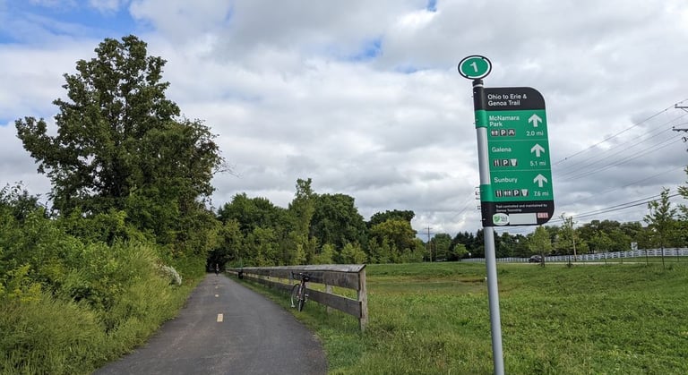
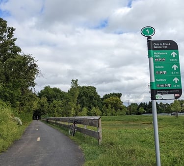
Cycling in Ohio: The OTET in the countryside. Photo: Jody Dzuranin at Ohio to Erie Trail
Terrain, logistics and caveats
The OTET’s surface varies from smooth asphalt to crushed stone, with occasional road connectors where the dedicated trail ends. Most sections are in good shape, though a few rural links can feel bumpy or overgrown. There is a mix of signage, since different counties manage different segments. Download the GPS map or carry a printed guide.
Amenities are generally good near towns — Mount Vernon, Westerville, and Columbus all offer food and lodging — but services thin out in between. You’ll find rest areas and trailheads every few miles, though not all have water or restrooms. Elevation changes are mild.
One downside is the on-road connectors in some portions; while most are on calm country lanes, a few follow busier roads where traffic can be tricky. The approach into Columbus can be busy, particularly on weekends, when joggers and families crowd the greenway. Weather is another factor. Ohio’s humidity can make mid-summer rides feel long, and heavy rain can leave some unpaved shoulders slick.
These are small trade-offs. Whether you ride a short stretch between towns or trace the full route from river to lake, it’s a fine ride from farmland to city skyline and back again. Among bike trails in Ohio, the OTET is at the top of the list.


Cycle Ohio trails in fine Buckeye style!
Ohio to Erie Trail
Distance: 326 miles total; 52 miles Mount Vernon to Columbus
The Ohio to Erie Trail (OTET) stretches from Lake Erie near Cleveland to the Ohio River in Cincinnati, covering roughly 326 miles. It passes through farmland, forested corridors, and a chain of small towns, connecting big-city destinations with rural landscapes. The segment from Mount Vernon to Columbus is a 52-mile stretch that shows off the region’s pastoral beauty and offers easy access to food, lodging and other amenities.
Open fields to striking skyline
Leaving Mount Vernon, you’ll roll past the restored CA&C Depot and Ariel-Foundation Park — a sprawling greenspace built on the site of an old glassworks factory that now features lakes, trails, and sculptural ruins. The trail is paved and well maintained, tracing gentle grades through farmland, patches of forest, and quiet backroads. You’ll cross old bridges, ride past small creeks, and occasionally share short road connectors before linking back to the main path.
Approaching Columbus, the ride gradually turns from countryside to suburb, and then to cityscape. The final miles follow the Scioto Greenway Trail, a riverfront corridor that threads directly into downtown and connects several parks, cafés, and scenic overlooks. One moment you’re pedaling through open fields, and the next you’re coasting alongside the skyline with the river beside you.
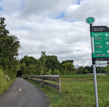
Cycling in Ohio: The OTET in the countryside. Photo: Jody Dzuranin at Ohio to Erie Trail
Terrain, logistics and caveats
The OTET’s surface varies from smooth asphalt to crushed stone, with occasional road connectors where the dedicated trail ends. Most sections are in good shape, though a few rural links can feel bumpy or overgrown. There is a mix of signage, since different counties manage different segments. Download the GPS map or carry a printed guide.
Amenities are generally good near towns — Mount Vernon, Westerville, and Columbus all offer food and lodging — but services thin out in between. You’ll find rest areas and trailheads every few miles, though not all have water or restrooms. Elevation changes are mild.
One downside is the on-road connectors in some portions; while most are on calm country lanes, a few follow busier roads where traffic can be tricky. The approach into Columbus can be busy, particularly on weekends, when joggers and families crowd the greenway. Weather is another factor. Ohio’s humidity can make mid-summer rides feel long, and heavy rain can leave some unpaved shoulders slick.
These are small trade-offs. Whether you ride a short stretch between towns or trace the full route from river to lake, it’s a fine ride from farmland to city skyline and back again. Among bike trails in Ohio, the OTET is at the top of the list.
Cycle Ohio trails in fine Buckeye style!
Some pages contain affiliate links. If you purchase something through one of these links, we may earn a small commission.