'Nutrition For Cyclists'
This comprehensive ebook is just $2.99!
Short Sections or End to End on the Schuykill River Trail
Philadelphia
Schuylkill River Trail
Distance: 75 miles
The Schuylkill River Trail runs about 75 miles, with long-term plans to extend it beyond 120 miles. The route follows the Schuylkill River from Philadelphia northwest through Montgomery and Chester counties toward Reading. Some sections are fully built and heavily used, while others remain in progress, so check conditions with the Schuylkill Greenways NHA before planning a long ride.
Most riders use the trail in sections rather than end to end. The best-known stretch runs through central Philadelphia, beginning near Schuylkill Banks. This portion includes a wide paved path along the river and the elevated boardwalk segment that extends over the water. Pavement is smooth, markings are clear, and usage is high. Commuters, runners, walkers, and cyclists share the corridor, particularly during weekday rush hours and weekend afternoons.
Downton sights, food and drink
From downtown, the trail passes close to several major landmarks. Short detours bring you near the Philadelphia Museum of Art and Boathouse Row. Food and drink options are easy to reach in Center City, and cafés near Walnut Street or 30th Street Station make convenient stops without adding significant distance. This urban section works well for shorter rides or transportation between neighborhoods.
Heading northwest toward Manayunk, the corridor narrows closer to the river. Rail lines run alongside the trail in places, and bridges cross overhead at intervals. In Manayunk, riders can exit directly into a compact main street with restaurants, coffee shops, and breweries. It is one of the easiest mid-ride stop locations along the route.
Beyond Manayunk, the surface varies. Some stretches remain paved, while others are crushed stone. Through Norristown and toward Phoenixville, traffic is generally not as heavy as in Philadelphia. Road crossings appear more frequently in certain towns, and signage ranges from clear to limited depending on the segment.
Lots of ride options
The Schuylkill River Trail is impressive partly because of how many communities it connects. It links parks, neighborhoods, commuter rail stations, and local business districts. Riders can structure outings as short urban loops or longer regional efforts. Parking is available at multiple trailheads outside Philadelphia, which allows you to begin in less congested areas.
Note that crowding in the Philadelphia section can slow you down, and heavy pedestrian traffic requires patience. Outside the city, incomplete gaps mean occasional on-road connections. After heavy rain, certain low-lying sections near the river may collect debris.
Whether you are commuting in Philadelphia, riding to lunch in Manayunk, or covering miles between suburban trailheads, the route offers distance, convenient access, and a nice river ride all rolled into one.


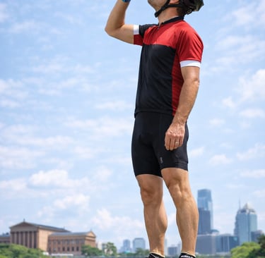
Cruising through Philadelphia on the Schuylkill River Trail. (AI Image).

Take the top step with this top-selling Camelback bottle!
Schuylkill River Trail
Distance: 75 miles
The Schuylkill River Trail runs about 75 miles, with long-term plans to extend it beyond 120 miles. The route follows the Schuylkill River from Philadelphia northwest through Montgomery and Chester counties toward Reading. Some sections are fully built and heavily used, while others remain in progress, so check conditions with the Schuylkill Greenways NHA before planning a long ride.
Most riders use the trail in sections rather than end to end. The best-known stretch runs through central Philadelphia, beginning near Schuylkill Banks. This portion includes a wide paved path along the river and the elevated boardwalk segment that extends over the water. Pavement is smooth, markings are clear, and usage is high. Commuters, runners, walkers, and cyclists share the corridor, particularly during weekday rush hours and weekend afternoons.
Downton sights, food and drink
From downtown, the trail passes close to several major landmarks. Short detours bring you near the Philadelphia Museum of Art and Boathouse Row. Food and drink options are easy to reach in Center City, and cafés near Walnut Street or 30th Street Station make convenient stops without adding significant distance. This urban section works well for shorter rides or transportation between neighborhoods.
Heading northwest toward Manayunk, the corridor narrows closer to the river. Rail lines run alongside the trail in places, and bridges cross overhead at intervals. In Manayunk, riders can exit directly into a compact main street with restaurants, coffee shops, and breweries. It is one of the easiest mid-ride stop locations along the route.
Beyond Manayunk, the surface varies. Some stretches remain paved, while others are crushed stone. Through Norristown and toward Phoenixville, traffic is generally not as heavy as in Philadelphia. Road crossings appear more frequently in certain towns, and signage ranges from clear to limited depending on the segment.
Lots of ride options
The Schuylkill River Trail is impressive partly because of how many communities it connects. It links parks, neighborhoods, commuter rail stations, and local business districts. Riders can structure outings as short urban loops or longer regional efforts. Parking is available at multiple trailheads outside Philadelphia, which allows you to begin in less congested areas.
Note that crowding in the Philadelphia section can slow you down, and heavy pedestrian traffic requires patience. Outside the city, incomplete gaps mean occasional on-road connections. After heavy rain, certain low-lying sections near the river may collect debris.
Whether you are commuting in Philadelphia, riding to lunch in Manayunk, or covering miles between suburban trailheads, the route offers distance, convenient access, and a nice river ride all rolled into one.
Cruising through Philadelphia on the Schuylkill River Trail. (AI Image).

Take the top step with this top-selling Camelback bottle!
Some pages contain affiliate links. If you purchase something through one of these links, we may earn a small commission.