'Nutrition For Cyclists'
This comprehensive ebook is just $2.99!

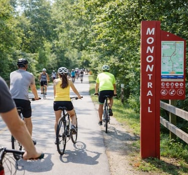
Cityscape Riding on Indy’s Monon Trail
Indianapolis
The Monon Trail
Distance: 27 miles
The Monon Trail is a 27-mile urban route that connects communities while also offering distance cyclists enough open space to clock a decent ride.
It is one of Indiana’s most heavily used rail-trails, running north–south through the heart of the Indianapolis metro area. Built along a former railroad corridor, it is a long urban spine, linking downtown neighborhoods with northern suburbs. Rather than isolating riders from the city, the route passes homes, shops, parks and busy intersections.
The southern end begins near downtown Indianapolis, where access points are frequent and street crossings appear often. This section moves through Broad Ripple, an active area known for restaurants, bars, and trail-adjacent businesses. Expect high pedestrian traffic here, especially during daylight hours. Signals and marked crossings help manage interactions with vehicles, but progress can be slow when the trail is crowded.
Smooth riding and plenty of amenities
North of Broad Ripple, the Monon continues into Carmel, where the corridor widens. Pavement along this part of the trail is excellent, signage is good, and amenities such as water fountains, restrooms, benches and public art are easy to find. Several parks and mixed-use developments sit directly on the trail, making stops for breaks convenient.
As the trail extends farther north into Westfield, the ride is quieter and more residential. Road crossings are spaced farther apart. This section attracts users looking to log longer distances without frequent interruptions.
The Monon gets high marks for navigation, with clear signage at major intersections and access points. Parking is plentiful near parks, trailheads, and commercial centers, allowing riders to choose starting locations based on distance goals or their tolerance for sometimes crowded sections. The trail is lighted along many urban segments – useful if you’re out in the early morning or evening – but that’s not the case on the entire route.
Ride with care in busy areas
Peak usage can be intense, particularly between downtown Indianapolis and Carmel, where walkers, runners, families, and cyclists all converge. Road crossings require attention and patience, even when signals are present. Those seeking a secluded ride or long stretches far removed from development may find the setting too busy.
Even with those constraints, the Monon Trail is a fine trail that connects communities, works well for running errands or commuting in some cases, while offering a long route through the metro area. For riders who value convenient access, upkeep, and the ability to tailor outings from short segments to an end-to-end effort, the Monon stands out as a well-used Indiana trail.
Cycling in Indianapolis along the Monon Trail


Stumped? Get the Urban Cycling Guide before you hit the trail!
The Monon Trail
Distance: 27 miles
The Monon Trail is a 27-mile urban route that connects communities while also offering distance cyclists enough open space to clock a decent ride.
It is one of Indiana’s most heavily used rail-trails, running north–south through the heart of the Indianapolis metro area. Built along a former railroad corridor, it is a long urban spine, linking downtown neighborhoods with northern suburbs. Rather than isolating riders from the city, the route passes homes, shops, parks and busy intersections.
The southern end begins near downtown Indianapolis, where access points are frequent and street crossings appear often. This section moves through Broad Ripple, an active area known for restaurants, bars, and trail-adjacent businesses. Expect high pedestrian traffic here, especially during daylight hours. Signals and marked crossings help manage interactions with vehicles, but progress can be slow when the trail is crowded.
Smooth riding and plenty of amenities
North of Broad Ripple, the Monon continues into Carmel, where the corridor widens. Pavement along this part of the trail is excellent, signage is good, and amenities such as water fountains, restrooms, benches and public art are easy to find. Several parks and mixed-use developments sit directly on the trail, making stops for breaks convenient.
As the trail extends farther north into Westfield, the ride is quieter and more residential. Road crossings are spaced farther apart. This section attracts users looking to log longer distances without frequent interruptions.
The Monon gets high marks for navigation, with clear signage at major intersections and access points. Parking is plentiful near parks, trailheads, and commercial centers, allowing riders to choose starting locations based on distance goals or their tolerance for sometimes crowded sections. The trail is lighted along many urban segments – useful if you’re out in the early morning or evening – but that’s not the case on the entire route.
Ride with care in busy areas
Peak usage can be intense, particularly between downtown Indianapolis and Carmel, where walkers, runners, families, and cyclists all converge. Road crossings require attention and patience, even when signals are present. Those seeking a secluded ride or long stretches far removed from development may find the setting too busy.
Even with those constraints, the Monon Trail is a fine trail that connects communities, works well for running errands or commuting in some cases, while offering a long route through the metro area. For riders who value convenient access, upkeep, and the ability to tailor outings from short segments to an end-to-end effort, the Monon stands out as a well-used Indiana trail.
Cycling in Indianapolis along the Monon Trail
Stumped? Get the Urban Cycling Guide before you hit the trail!
Some pages contain affiliate links. If you purchase something through one of these links, we may earn a small commission.