'Nutrition For Cyclists'
This comprehensive ebook is just $2.99!

The 10 Best Urban Bike Trails In The U.S.
Discover the best urban bike trails across America with our comprehensive listing of the top 10 urban bike paths. Find one near you and experience the best urban riding in the U.S.!
5/29/202612 min read


Across the United States, a growing network of paved greenways and rail-trails is changing how cyclists experience urban environments. These routes are transportation alternatives and destinations in themselves, as more and more cyclists discover a new way to enjoy the cities where they live and visit. Among the 10 best urban cycling trails in the U.S., some follow rivers that have shaped cities for centuries, and others trace old rail lines or circle iconic landmarks. Many pass cafés, markets, and neighborhoods that offer a break and a chance to experience the local culture.
This list, compiled by Bike Trail Journal, highlights routes that stand out for their access, scenery, and the way they showcase the cities they run through. Each offers a different kind of ride, but they all make it easy to experience a city on a bike.
1. Louisville Loop — Louisville, Kentucky
Trail Stats
Length: 100+ miles planned (major sections complete)
Surface: Paved
Route Type: Citywide loop system
Primary Use: Long rides, route variety
Louisville does trail cycling right. The Louisville Loop is a growing system designed to circle the city through parks, riverfront paths and greenspaces. Completed sections allow riders to link long routes across very different parts of the city. There is plenty of choice among trailheads, which are spread throughout the corridor. The overall scale and reach place this system at the top of the list. Plans call for the trail to eventually encircle Louisville Metro, linking neighborhoods, parks and civic attractions.
2. Hudson River Greenway — New York
Trail Stats
Length: 13 miles
Surface: Paved
Route Type: Waterfront greenway
Primary Use: High-volume transportation
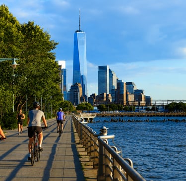
The Hudson River Greenway runs along Manhattan’s west side from the Battery northward. This being New York, you would expect traffic woes, but keeping riders mostly away from cars is one of the route’s attractions. That keeps the sometimes-high number of riders moving and away from streets. Pier parks, river access and skyline views remind riders that they are indeed in the Big Apple. While the trail can be quite busy at times, the ability to cross Manhattan without mixing with cars places this trail among the strongest urban systems in the U.S. The Hudson River Greenway Trail System is a part of the Empire State Trail, the nation's longest multi-use state trail, spanning 750 miles.
3. San Antonio River Trail — San Antonio, Texas
Trail Stats
Length: 65+ miles
Surface: Paved
Route Type: River corridor trail
Primary Use: Distance riding, commuting
The San Antonio River Trail extends well beyond the downtown River Walk, offering long off-street mileage through the Mission Reach and outer greenways. Wide pavement marks most of the route and there are a limited number of crossings to hamper a steady ride. Historic missions, river overlooks and restored river sections line the route. Services thin out outside the urban core, and navigation between segments can take a little planning, but the amount of uninterrupted mileage within city boundaries makes for nice cruising. And don’t forget your River Walk map.
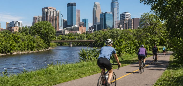
4. Minneapolis Grand Rounds — Minneapolis, Minnesota
Trail Stats
Length: 50+ miles
Surface: Paved
Route Type: Parkway and off-street network
Primary Use: Long rides, loop routes
The Grand Rounds system forms a loop around Minneapolis, tying together lakes, river corridors and parkland. It’s unique in that riders can put together routes of varying length without repeating streets. Despite the area’s harsh winters, the trail remains well-maintained. Some segments follow low-speed park roads rather than separated paths, which calls for a heads-up. This is a great route – especially during the warm months – for racking up miles while staying in the city limits. As the National Scenic Byway Association puts it, “The Grand Rounds is one of the country’s longest continuous systems of public urban parkways and has been the preeminent urban parkway system for more than a century. It is also an excellent bike ride.”
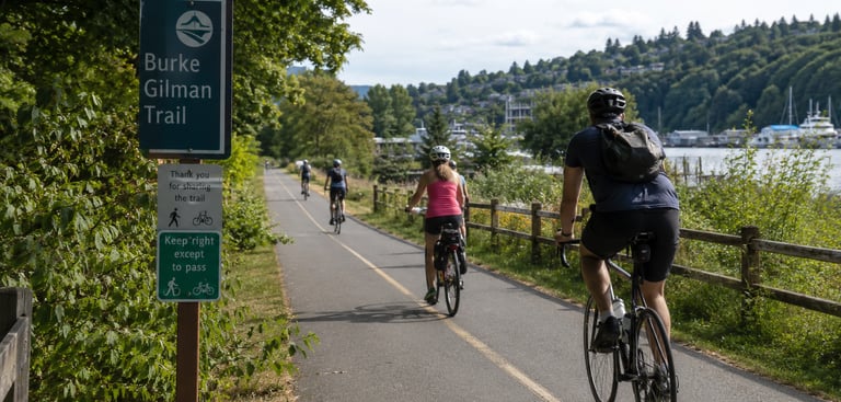
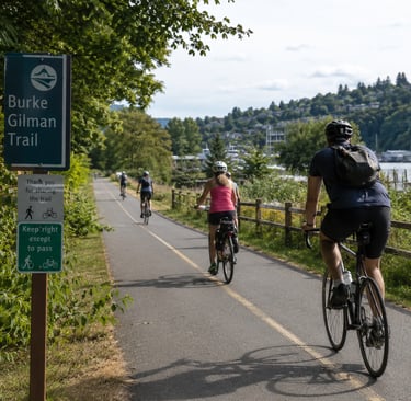
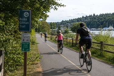
5. Burke-Gilman Trail — Seattle, Washington
Trail Stats
Length: 20 miles
Surface: Paved
Route Type: Multi-use urban path
Primary Use: Transportation, endurance riding
The Burke-Gilman Trail runs along Seattle’s waterways and neighborhoods, linking parks, campuses, and residential areas. It’s generally a flat ride along a well-paved route. You can’t beat the marinas, shoreline access and greenspace that lines much of the path. Congestion can slow things a little near Fremont and university areas, and some of the industrial crossings do require attention. Even so, this trail deserves its recognition in a city that appreciates a non-motorized route that avoids its sometimes-snarled motorways. Before it became a cycling route, the Burke-Gilman Trail was an economic lifeline for communities.
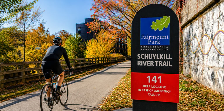
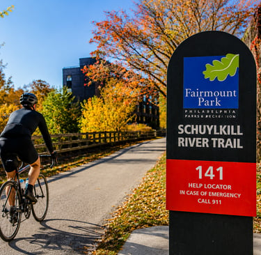
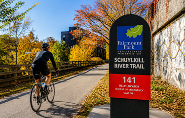
6. Schuylkill River Trail — Philadelphia, Pennsylvania
Trail Stats
Length: 30+ miles
Surface: Paved
Route Type: Riverfront trail
Primary Use: Fitness riding, commuting
The Schuylkill River Trail skirts the river through Philadelphia. Extended segments are free from street crossings, always a welcome feature for trail cyclists. Wide pavement and boardwalks make riding near the city center a breeze. The route links universities, museums, office districts, and parks while remaining off-road. Take care near Center City, where trail traffic can become heavy and passing requires a little patience. Farther from downtown, things thin out as the trail continues into suburbia. The trail connects a number of towns, making it an urban trail star.
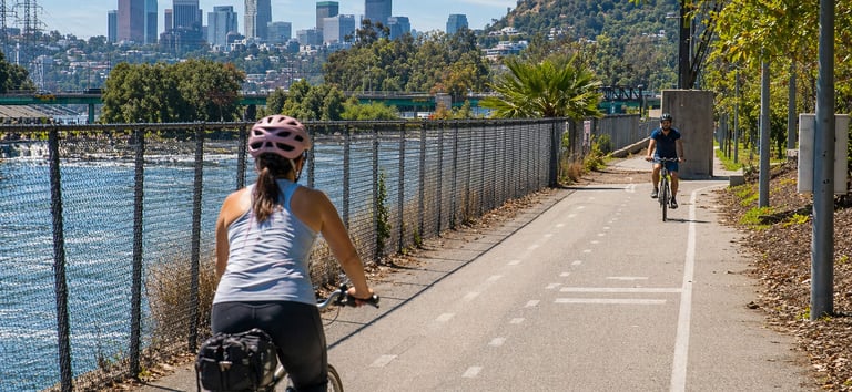
7. Los Angeles River Bike Path — Los Angeles, California
Trail Stats
Length: 32 miles (multiple segments)
Surface: Paved
Route Type: River corridor trail
Primary Use: Transportation, distance riding
The Los Angeles River Bike Path follows the concrete river channel through several neighborhoods, including Griffith Park and the San Fernando Valley. Long stretches allow riders to cover miles without traffic worries. You do have to be alert for connections between sections, which are not always obvious. Scenery alternates between green parkland and industrial areas. The amount of off-street mileage within city limits makes this one of the longest urban cycling corridors in the country. Trailhead directions are here.
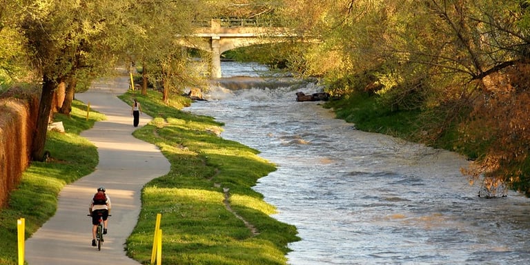
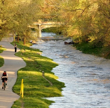
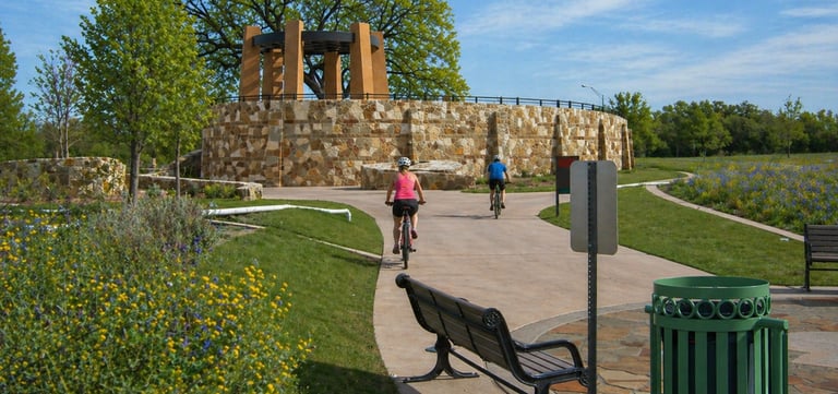
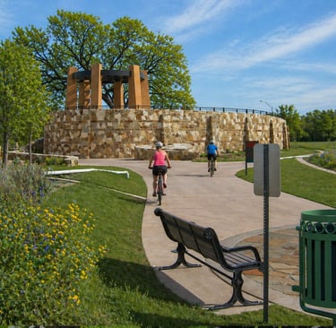
8. Cherry Creek Trail — Denver, Colorado
Trail Stats
Length: 40+ miles
Surface: Paved
Route Type: Creekside urban trail
Primary Use: Commuting, long urban rides
The Cherry Creek Trail traces the creek corridor from downtown Denver deep into the southeastern suburbs. A big plus - much of the route runs below street level, keeping riders away from traffic and major intersections. Grades are mild, and the underpasses keep the route moving across major roads. Urban sections are busy with mixed use, while suburban miles generally offer some breathing room. Connections to downtown paths and regional routes make for extended city-based riding. Plenty of route for a full day of riding. The trail also connects with a popular shopping district.
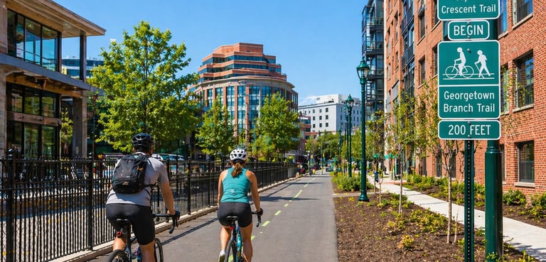
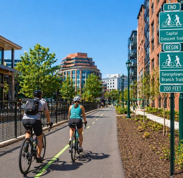
9. Capital Crescent Trail — Washington, D.C. & Maryland
Trail Stats
Length: 11 miles
Surface: Paved and crushed stone
Route Type: Rail corridor / canal-adjacent path
Primary Use: Commuting, distance riding
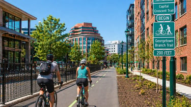
Beginning near Georgetown’s waterfront, the Capital Crescent Trail follows an old rail route northwest toward Bethesda. The paved section is separated from traffic, while the crushed-stone part of the trail begins after the Dalecarlia Tunnel. Road crossings are few, which all cyclists love. Congestion increases near Georgetown and Bethesda during peak hours. Bethesda brings you to transit options, dining, and regional trail systems if you’re ending your day here. But most treat this is a fine out-and-back ride, 22 miles of nice trail and a special ride when the weather cooperates. If you’re visiting the nation’s capital, consider sightseeing by bike. The Coalition for the Capital Crescent Trail promotes advocacy for the trail, including current efforts for widening and paving.
10. Monon Trail — Indianapolis, Indiana
Trail Stats
Length: 27 miles
Surface: Paved
Route Type: Rail corridor
Primary Use: Transportation, fitness riding
The Monon Trail runs north from downtown Indianapolis through Broad Ripple, Carmel, and Westfield along a former rail line. Its easy access makes it a top choice, allowing riders to join from neighborhoods, side streets, and business districts without searching for trailheads. Riders find nice pavement, and crossings are usually well controlled. Central sections see heavy mixed use that limits speed during busy hours, while northern miles open things up. Services, parks, and local destinations sit close by throughout the route. If you’re in Indy, it’s well worth a ride along this popular trail. The origin of the trail began in 1883 when rail tracks were laid for trains traveling to Chicago.
Did we miss your favorite?
Bike Trail Journal wants to hear about your favorite trail. Leave a comment or write us at contact@biketrailjournal.com.
The 10 Best Urban Bike Trails In The U.S.


Cherry Creek (Photo Dan Long)


Across the United States, a growing network of paved greenways and rail-trails is changing how cyclists experience urban environments. These routes are transportation alternatives and destinations in themselves, as more and more cyclists discover a new way to enjoy the cities where they live and visit. Among the 10 best urban cycling trails in the U.S., some follow rivers that have shaped cities for centuries, and others trace old rail lines or circle iconic landmarks. Many pass cafés, markets, and neighborhoods that offer a break and a chance to experience the local culture.
This list, compiled by Bike Trail Journal, highlights routes that stand out for their access, scenery, and the way they showcase the cities they run through. Each offers a different kind of ride, but they all make it easy to experience a city on a bike.
1. Louisville Loop — Louisville, Kentucky
Trail Stats
Length: 100+ miles planned (major sections complete)
Surface: Paved
Route Type: Citywide loop system
Primary Use: Long rides, route variety
Louisville does trail cycling right. The Louisville Loop is a growing system designed to circle the city through parks, riverfront paths and greenspaces. Completed sections allow riders to link long routes across very different parts of the city. There is plenty of choice among trailheads, which are spread throughout the corridor. The overall scale and reach place this system at the top of the list. Plans call for the trail to eventually encircle Louisville Metro, linking neighborhoods, parks and civic attractions.
2. Hudson River Greenway — New York
Trail Stats
Length: 13 miles
Surface: Paved
Route Type: Waterfront greenway
Primary Use: High-volume transportation
The Hudson River Greenway runs along Manhattan’s west side from the Battery northward. This being New York, you would expect traffic woes, but keeping riders mostly away from cars is one of the route’s attractions. That keeps the sometimes-high number of riders moving and away from streets. Pier parks, river access and skyline views remind riders that they are indeed in the Big Apple. While the trail can be quite busy at times, the ability to cross Manhattan without mixing with cars places this trail among the strongest urban systems in the U.S. The Hudson River Greenway Trail System is a part of the Empire State Trail, the nation's longest multi-use state trail, spanning 750 miles.
3. San Antonio River Trail — San Antonio, Texas
Trail Stats
Length: 65+ miles
Surface: Paved
Route Type: River corridor trail
Primary Use: Distance riding, commuting
The San Antonio River Trail extends well beyond the downtown River Walk, offering long off-street mileage through the Mission Reach and outer greenways. Wide pavement marks most of the route and there are a limited number of crossings to hamper a steady ride. Historic missions, river overlooks and restored river sections line the route. Services thin out outside the urban core, and navigation between segments can take a little planning, but the amount of uninterrupted mileage within city boundaries makes for nice cruising. And don’t forget your River Walk map.
4. Minneapolis Grand Rounds — Minneapolis, Minnesota
Trail Stats
Length: 50+ miles
Surface: Paved
Route Type: Parkway and off-street network
Primary Use: Long rides, loop routes
The Grand Rounds system forms a loop around Minneapolis, tying together lakes, river corridors and parkland. It’s unique in that riders can put together routes of varying length without repeating streets. Despite the area’s harsh winters, the trail remains well-maintained. Some segments follow low-speed park roads rather than separated paths, which calls for a heads-up. This is a great route – especially during the warm months – for racking up miles while staying in the city limits. As the National Scenic Byway Association puts it, “The Grand Rounds is one of the country’s longest continuous systems of public urban parkways and has been the preeminent urban parkway system for more than a century. It is also an excellent bike ride.”
5. Burke-Gilman Trail — Seattle, Washington
Trail Stats
Length: 20 miles
Surface: Paved
Route Type: Multi-use urban path
Primary Use: Transportation, endurance riding
The Burke-Gilman Trail runs along Seattle’s waterways and neighborhoods, linking parks, campuses, and residential areas. It’s generally a flat ride along a well-paved route. You can’t beat the marinas, shoreline access and greenspace that lines much of the path. Congestion can slow things a little near Fremont and university areas, and some of the industrial crossings do require attention. Even so, this trail deserves its recognition in a city that appreciates a non-motorized route that avoids its sometimes-snarled motorways. Before it became a cycling route, the Burke-Gilman Trail was an economic lifeline for communities.
6. Schuylkill River Trail — Philadelphia, Pennsylvania
Trail Stats
Length: 30+ miles
Surface: Paved
Route Type: Riverfront trail
Primary Use: Fitness riding, commuting
The Schuylkill River Trail skirts the river through Philadelphia. Extended segments are free from street crossings, always a welcome feature for trail cyclists. Wide pavement and boardwalks make riding near the city center a breeze. The route links universities, museums, office districts, and parks while remaining off-road. Take care near Center City, where trail traffic can become heavy and passing requires a little patience. Farther from downtown, things thin out as the trail continues into suburbia. The trail connects a number of towns, making it an urban trail star.
7. Los Angeles River Bike Path — Los Angeles, California
Trail Stats
Length: 32 miles (multiple segments)
Surface: Paved
Route Type: River corridor trail
Primary Use: Transportation, distance riding
The Los Angeles River Bike Path follows the concrete river channel through several neighborhoods, including Griffith Park and the San Fernando Valley. Long stretches allow riders to cover miles without traffic worries. You do have to be alert for connections between sections, which are not always obvious. Scenery alternates between green parkland and industrial areas. The amount of off-street mileage within city limits makes this one of the longest urban cycling corridors in the country. Trailhead directions are here.
8. Cherry Creek Trail — Denver, Colorado
Trail Stats
Length: 40+ miles
Surface: Paved
Route Type: Creekside urban trail
Primary Use: Commuting, long urban rides
The Cherry Creek Trail traces the creek corridor from downtown Denver deep into the southeastern suburbs. A big plus - much of the route runs below street level, keeping riders away from traffic and major intersections. Grades are mild, and the underpasses keep the route moving across major roads. Urban sections are busy with mixed use, while suburban miles generally offer some breathing room. Connections to downtown paths and regional routes make for extended city-based riding. Plenty of route for a full day of riding. The trail also connects with a popular shopping district.
9. Capital Crescent Trail — Washington, D.C. & Maryland
Trail Stats
Length: 11 miles
Surface: Paved and crushed stone
Route Type: Rail corridor / canal-adjacent path
Primary Use: Commuting, distance riding
Beginning near Georgetown’s waterfront, the Capital Crescent Trail follows an old rail route northwest toward Bethesda. The paved section is separated from traffic, while the crushed-stone part of the trail begins after the Dalecarlia Tunnel. Road crossings are few, which all cyclists love. Congestion increases near Georgetown and Bethesda during peak hours. Bethesda brings you to transit options, dining, and regional trail systems if you’re ending your day here. But most treat this is a fine out-and-back ride, 22 miles of nice trail and a special ride when the weather cooperates. If you’re visiting the nation’s capital, consider sightseeing by bike. The Coalition for the Capital Crescent Trail promotes advocacy for the trail, including current efforts for widening and paving.
10. Monon Trail — Indianapolis, Indiana
Trail Stats
Length: 27 miles
Surface: Paved
Route Type: Rail corridor
Primary Use: Transportation, fitness riding
The Monon Trail runs north from downtown Indianapolis through Broad Ripple, Carmel, and Westfield along a former rail line. Its easy access makes it a top choice, allowing riders to join from neighborhoods, side streets, and business districts without searching for trailheads. Riders find nice pavement, and crossings are usually well controlled. Central sections see heavy mixed use that limits speed during busy hours, while northern miles open things up. Services, parks, and local destinations sit close by throughout the route. If you’re in Indy, it’s well worth a ride along this popular trail. The origin of the trail began in 1883 when rail tracks were laid for trains traveling to Chicago.
Did we miss your favorite?
Bike Trail Journal wants to hear about your favorite trail. Leave a comment or write us at contact@biketrailjournal.com.
The 10 Best Urban Bike Trails In The U.S.


Cherry Creek (Photo Dan Long)


Some pages contain affiliate links. If you purchase something through one of these links, we may earn a small commission.